The image analysis (circulated and provided to Al-Jazeera TV) was done with WorldView-1 & QuickBird satellite imagery (by UNOSAT) which are acquired from 450 – 500 Km from the earth. Most of the analysis was done probably based on object oriented classification algorithm which interprets an image based on size, shape, colour and other attributes of ground features and the rest of the analysis was purely based on visual interpretations by a group who are totally alien to ground situation in CSZ. Therefore, it is not possible to provide conclusive interpretation based on these analyses without a detailed ground assessment being carried out. Conclusions drawn from the interpretations of these images have no scientific validity.
Further, assessment by UNITAR/UNOSAT – 26 April 2009 refers only to the following two areas. Damages Inside CSZ:
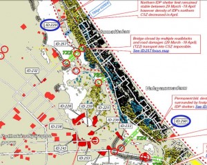
1. Putumattalan: Three permanent buildings have been destroyed between 29 March and 19 April, bringing the total for the northern section of the CSZ to six destroyed since 15 March.
Our comment: The terrorist occupy this area with a large dump of arms and ammunitions, which were earlier distributed over 15000 km2 area held by them. This sort of concentration of arms and ammunition handled by newly recruited terrorists could easily be attributed to the damage shown on the images.
There are potentially large amounts of moderate to severe damages to the remaining permanent buildings in this area
Our comment: this is not verified by images
2. Valayanmadam: one additional permanent building has been destroyed, and further South there is a cluster of likely impact craters within an area previously densely populated with IDP shelters.
Our comment: IDP shelters in the area have been removed and only one permanent building has been shown to be destroyed. This can also be due to terrorist activity
Comments on some of the images shown (with image numbers)
1. Most of the damaged sites shown on image views are outside the CSZ.
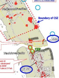
2. ID 256 is outside the CSZ. Vadduwakkalu is located outside the CSZ as shown by UNOSAT map (slide2).
3. ID 259 is also outside CSZ. Although it shows a few craters, there is no evidence that Sri Lankan army shelled this area.
4. ID 250 shows a damaged building where only the structure exists on April 19. However, it is noted that large number of temporary IDP shelters are disappeared on April 19 image compared to the March 29 image. Therefore, the statement that ‘the damage is due to shelling’ is not acceptable. If that is the case, what happened to the IDP shelters ? 
5. ID 229 shows some buildings appear to be damaged. But there is no image to make a comparison.
General disagreements on the interpretation of imagery
During the Iraqi war, USA used spy satellites and American reconnaissance spacecraft with ultra violet, optical, infrared and radar sensors (all 4 types) and the image interpretation was assisted by the experts who had ground knowledge and military strategies. In spite of all the gathered knowledge from physical sensors, human knowledge and interpretation skills, Sadam Hussains dummy weapons were targeted and destroyed. This points to the fact that satellite data interpretation would only be useful after ground verifications.
U.S. ‘Almost All Wrong’ on Weapons: Report on Iraq Contradicts Bush Administration Claims’ carried an article in Washington Post in 2004 October 07. “A controversy has existed over the performance of U.S. (and British) intelligence in collecting and evaluating information about Iraqi weapons of mass destruction programs. The reliability of sources has been questioned. It has been suggested that some human intelligence may have been purposeful deception by the Iraqi intelligence and security services, while exiles and defectors may have provided other intelligence seeking to influence U.S. policy.”(www.gwu.edu/~nsarchiv/NSAEBB/NSAEBB80) (What we see on imagery could even be a ploy by LTTE to show international community how the damages have taken place in CSZ).
Ranjith Premalal De Silva, PhD ( UK )
Professor of Satellite Remote Sensing and GIS
Head, Department of Agricultural Engineering
University of Peradeniya.